The Met Office has issued new yellow weather warnings spanning 14 hours as the UK freezes in bone-chilling temperatures.
Snow and ice are likely to cause further disruption overnight Wednesday (January 7) through Thursday morning (January 8), the Met Office said.
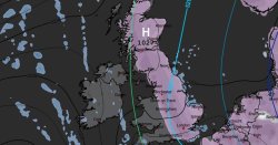
According to their latest forecast, "ice will develop fairly widely on Wednesday night into Thursday morning, with partially thawed lying snow refreezing readily. In addition, wintry showers across Orkney and northeast Scotland will slowly clear away to the east, whilst a new band of mainly light rain, sleet and snow will arrive from the west".
Snow is expected at low levels at first, away from coasts, before becoming confined to ground above around 300 metres. The west of Scotland and the north of England are the areas more likely to see 1-2 cm of fresh snow with 2-5cm of accumulations on ground above 200-300 metres.
The forecast also read: "Strong winds could lead to continued drifting or blowing snow in places. Accumulations over lower elevations, coastal areas, and over Orkney and Harris are expected to be lower, but ice is expected to remain a hazard on Wednesday morning and again on Wednesday night, particularly where snow melts during the day and refreezes overnight."
Heavy snow in the first part of the week led to hundreds of schools being closed across northern Scotland on Tuesday, and while many are set to reopen on Wednesday, disruption continues in many areas.
This includes Aberdeenshire, where all schools and council-run nurseries will remain closed, along with dozens of schools in Moray and Aberdeen and a number of those in Orkney and Shetland.
Several yellow weather warning for ice and snow have also been issued for the northern half of the country today (Wednesday, January 7), which will remain in place until 11.59pm.
Storm Goretti may also bring a spell of very strong winds from Thursday (January 8), and the Met Office has issued an amber warning for the south west of England.
Their latest forecast added: "Storm Goretti may bring a short period of exceptionally strong northwesterly winds to the Isles of Scilly and parts of Cornwall on Thursday evening, with peak gusts potentially of 80-90 mph in exposed areas. This will depend on the exact track of Storm Goretti, and should the low pressure system track further south then the risk of these very strong winds would reduce."